
The Centennial Trail #89 got its number from the year of South Dakota’s statehood, 1889. Construction of the 111 mile long trail began in 1989 in celebration of the state’s 100 year anniversary. The trail begins in the prairie grasslands near Bear Butte State Park and travels southward into the Black Hills forest until it reaches Wind Cave National Park near Hot Springs.
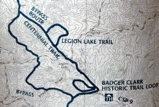
For this hike we trekked a section of the Centennial Trail found near the Badger Hole Trailhead. This area connects to a bypass route, effectively creating a loop trail. We stuck to the section of this loop found south of Highway 16A, making for a 2.5 mile hike of a little under 2 hours. From my estimation, crossing over 16A and continuing on to take the full loop would increase your hike to about 4 miles.

We begin our hike at the Legion Lake Lodge along Highway 16A in Custer State Park. During the busy summer months this parking lot could be full, in which case a good alternative starting point is at the Badger Hole Trailhead. This trailhead can be found by continuing east on 16A, turning south onto Park Road 9. Follow this road for 1 mile and take a right onto Badger Hole Drive. You will find the Badger Hole Trailhead on your left hand side.
")
")
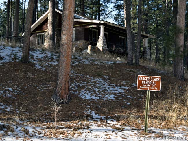
Starting at Legion Lake cut through the deck area and walk along the left side of the lake, passing by the resort’s beach and playground area. After walking past a bridge, continue south on the trail following the Galena Creek. You will hit an overflow parking area marked with a few large rocks on the trail. A few minutes further down this road and you will find the Badger Clark Memorial and Badger Hole Trailhead to the right.
Here there are two different trails. The Badger Clark Historic Trail is a loop found up on the hill by Badger Clark’s cabin. The Centennial Trail is to the left of this hill, which opens up into a small prairie grass area before entering into a mixed wood forest of aspen, oaks, and various conifers.
")
")
About a half mile from the Badger Hole Trailhead we come to a crossroads. There is the path continuing south toward the French Creek Trailhead, or where we want to go to the right, west along the bypass route back toward 16A. Here we hiking along a stream and pass through Sheep Draw before starting a steady uphill climb.
")
")
During this hike there is an elevation gain of approximately 200 feet, most of which is within the next quarter of a mile or so. At the top of our ascent there’s a large rocky outcrop that can be climbed up onto for some views of the surrounding landscape.
")
")
Continuing along the trail you pass by an old logging area. You will see a sign marking the spot. There’s a logging road to the left, whereas the hiking trail veers off to the right in a north easterly direction. Here begins the descent back down the hill and toward the highway.
")
")
After crossing a small stream the trail opens up to highway 16A. From here you can cross over the highway and continue north on the Centennial Trail past the Centennial Cabin and toward the Iron Creek Trailhead. You will eventually hit a trail junction heading right that will bring you back around to the Legion Lake Campground to complete the longer loop. Otherwise it’s a 1/4 mile trek along the road toward the east to return to the Legion Lake parking lot.
